Roman Festival Trail
Visiting Roman Chester

The natural and extensive anchorage which once existed on the site of the Roodee may well have influenced the Roman choice to build a fort here and it is possible that a flotilla of the "Classis Britannica" was stationed at Chester. One of Chester's Roman tombstones is that of a newly promoted centurion who "naufragio perit" (perished in a shipwreck). In case the body was recovered, there is a space on the tombstone for the words "Lies Here" to be inserted - but they were never added. A sandstone "quay" at the Roodee is often identified as part of the "Roman docks" although this is now thought to be a later Roman defensive structure, with the actual dock being a wooden platform at then end of a large pier-like structure extending from the "quay" out across the tidal mudflats that then occupied the site of the present day racecourse.
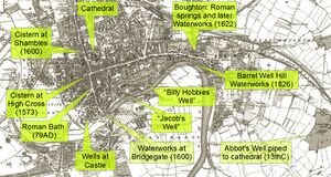
The site of the City had many practical advantages for the Romans. Here was the tidal limit where a ford was practicable and safe. The elevated sandstone ridge on which the City was founded was dry and proof against flooding, but a water supply could be obtained from springs at nearby Boughton and piped in. Building stone of a perhaps only passable quality could be quaried locally and bricks could be made from the glacial boulder clay to the north and east of the city. The site was well-protected by the rivers curve around the southern and western flanks. Marshes protected the city to the south-west (Saltney) and north-east (Gowy), but were sufficiently distant that malaria and other swamp-related issues were few. Although well-protected by these natural features, the City could be approached without difficulty from the south and east.
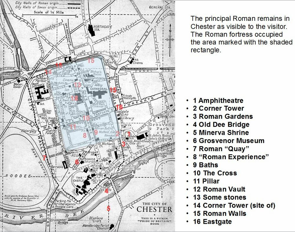
There are a lot of Roman remains in Chester. Some are well marked and easy to find, others not so. This is a brief guide to the ones which can be found by the interested visitor. The map above (based on a 1950's map of Chester) can be printed off for reference when visiting. There are other "trails" round Chester including the Millennium festival trail which take in some of the same locations as well as many non-Roman locations. This Roman Trail "starts" at the Amphitheatre but can be joined anywhere. Descriptions here are only brief - much more information can be found on the Roman Chester page. For a detailed guide to the remains we would suggest "Roman Chester - City of the Eagles" by David J. P. Mason, copies of which can be purchased at the Grosvenor Museum.
The "not to be missed" elements of a visit are the Roman parts of the City Walls, the Amphitheatre (and the nearby Roman Gardens), the Minerva Shrine and the Grosvenor Museum - all of which can be visited for free. We have included some "nearby non-Roman" elements in the tour for information. The tour starts at the Amphitheatre.
The Amphitheatre

No-one knew for certain that Chester had an amphitheatre until 1929, when a large curved wall appeared while an underground boiler room was being built onto the south side of Dee House, an eighteenth-century town house used as a convent school for girls. A local schoolmaster, W. J. Williams (his nickname was "Walrus") was the first to recognise what this meant. Williams identified a stretch of masonry exposed in June 1929 as the outer wall of the amphitheatre. The curving wall and the buttresses were the main features that suggested that this was the amphitheatre, the ruins of which proved to be well preserved. In the early 1930s, parts of the western entrance, the outer wall, the arena walls and the arena itself were discovered.
Only a little over half of the Amphitheatre has been excavated. The rest remains under Dee House, which is a grade-II listed building and owned by the local council. The building, which appears to have little architectural merit compared to the Amphitheatre, has been dangerously derelict for many years, but the council appears (in 2015) to be proposing to have the building repaired and put up for a 150-year lease. Therefore, it appears there is little chance that the rest of the Amphitheatre (which is the largest known in Britain) will be excavated.
Around 893, a fresh wave of Danes crossed to England in 330 ships of two divisions and attacked. An attempt to break through the English lines failed and, after collecting reinforcements, the Danes made a forced march across England to occupy the ruined Roman fortress of Chester, arriving late in the year. The Victorian work Picturesque England describes the Chester fortifications at this time of being a round sandstone castle:
- The Danes, the following and more terrible invaders, who had been allowed by Alfred the Great to settle in Northumberland, next assailed Chester, and seized the fortress, which was circular and of red stone...
This may be an assumption on the part of the author that the present works are older than they actually are (his source is unknown). However a more interesting possibility is that the "fortress" was in fact the remains of the amphitheatre.
sources and links
- The ongoing debate about the Amphitheatre;
- Chester Amphitheatre Project - includes links to the news-letters about the excavation;
- Thompson, FH, ‘The excavation of the Roman amphitheatre at Chester’, Archaeologia (1976), 105, 127–239;
Near-by non-Roman
- St Johns - Chester's first Cathedral - with spectacular ruins at either end, medieval frescos (please do not phograph with flash) and interesting stained glass among many other features of interest - there are no fancy electronic guides to hire here - just very comprehensive signage and cups of tea available at truly ancient prices;
Corner Tower on the City Walls
- Leave the Amphitheatre and head towards the Newgate (the arch with a tower at each end). Next to the Newgate is the Peppergate or Wolfgate, and next to that is the base of the Roman corner tower, in front of the City Walls.
The Roman Corner Tower might give the impression that these towers were located on the outside of the City Walls. In fact the Corner Towers were located on the inside of the walls, and in centuries of re-building the wall has moved the line of the wall backwards.
The remaining base of the former south-east angle tower dates from the late first to early second century. It is purple-grey ashlar sandstone and trapezoidal in plan. Parts of a base-course are visible, then 2 weathered plinth-courses and parts of an ashlar facing course above, with the rubble core and parts of the coursed rubble inner face rising a little higher. The outer face is segmental in plan to coincide with the quadrant corner of the former fortress wall. Also present are part foundations of an adjoining chamber within the former wall-line west of the tower. The remains of the tower and adjoining fragment of the Roman wall are bonded together, hence built at the same time.
It was here that the City Walls of Roman Chester turned westwards. The extension of the walls down to the River Dee dates from the late Dark Ages well after the Romans had left.
Near-by non-Roman
- Pepper Street - site of a Spitfire factory from WW2;
- The City Walls
Roman Gardens
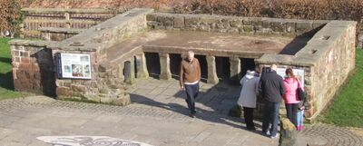
- Cross the road from the corner tower and enter the Roman Gardens.
This collection of pillars and other Roman remains were in fact, assembled in 1949 from bits and pieces of Roman artifacts found throughout Chester. None of the building fragments originally came from the present site. The project was initiated as Chester's contribution to the 1951 Festival of Britain. The gardens were re-modeled in 2000 to provide a path down to the River Dee.
Most of the columns that can be seen in the Roman Gardens came from the exercise hall of the Roman bath house (thermae) in Bridge Street following excavations in 1863. They were once 6 meters tall and supported the stonework of the central section of the hall. The largest column currently in the Roman Gardens came from the assembly hall of the headquarters building (Principia).
The Roman Gardens also houses a reconstructed hypocaust which was the Roman system of under floor heating. An under floor cavity was filled with hot air from a furnace to heat the rooms or baths above. Several hypocausts have been found in excavations in Chester. The hypocaust in the Roman Gardens has been reconstructed using the pillars (pilae) recovered in 1863 from one of the rooms in the main bath building (thermae) of the Roman fortress in Bridge Street.
The "capricorn" mosaic is a reproduction of the Ostia style mosaic unearthed in Chester city centre which was laid within the Roman Bath House. The original of this mosaic was destroyed at the time of the contractors excavations (to build the Grosvenor Shopping Center) in the 1960s. The capricorn symbol was used by the Legio II Adiutrix - who were stationed in Chester from its foundation as a permanent fortress until around 87AD and it was this legion that built the original fortress. The same symbol was also used by Legio XX, but its use appears to have been discontinued at the end of the first century.
Sources and links
- Chester Antiquary on the Roman Gardens;
Near-by non-Roman
- Park Street - where a coin of Edward VI was mistaken for a Roman coin - just because it is written in latin doesn't mean it is Roman!
The River Dee
- Continue through the Roman Gardens and head downhill towards the River Dee. At the river you have a choice: either head downstream to the Old Dee Bridge directly or head upstream towards the Suspension Bridge for a look at the Hermitage and the collection of relics just inside Grosvenor Park. None of these relics are Roman although it is thought that a further Roman baths may have existed hereabouts. There was a noted spring (known as "Jacobs Well") on the site of what is now a public toilet and the stonework from this spring is one of the relics in Grosvenor Park. If you choose to head towards the Suspension Bridge, then cross the river and head downstream on the southern bank to arrive at the Old Dee Bridge.
The River Dee was one reason the Romans located their fortress where they did, at the lowest fordable point in the river. It is possible that the stretch of river between the Old Dee Bridge and Heronbridge was not navigable prior to the construction of the Norman weir, as the Roman appear to have unloaded boats on the upper river at Heronbridge and transported goods from there by road. In Roman times there used to be over three times the amount of water flowing through the “Chester Gorge” where the weir is currently located, but nowadays only 30% of the River Dee actually reaches Chester, the rest is abstracted for various purposes upstream of Chester.

Near-by non-Roman
- The Hermitage - supposed residence of King Harold after he survived the Battle of Hastings;
- Grosvenor Park - site of the relocated Jacobs Well which was once associated with a spring which may have supplied a Roman bath;
- The Suspension Bridge - this 1923 bridge bears a striking resemblance to the 1922 Porthill Bridge in Shrewsbury.
Old Dee Bridge
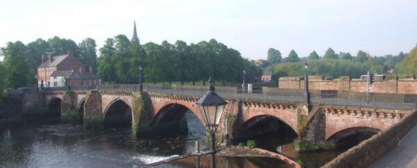
The present bridge over the River Dee replaced earlier medieval bridges, probably of timber, and is believed to stand just upstream of the site of a Roman bridge (see Roman Chester), which probably had stone piers carrying a timber carriageway. The remains of the bases of the Roman piers are said to be visible in the river bed just downstream of the present bridge. The precise date at which the Romans began construction at Chester has been the subject of much debate. According to one version, sometime around 74 CE, the then governor of Roman Britain, Sextus Julius Frontinus constructed an "auxiliary fort" at Deva Victrix (Chester). The placement of this fort (at the lowest ford of the Dee) appears to have been a strategic move by Frontinus with the intent of both blocking the route of any routed British trying to escape to the north, and to guard against help arriving from the Brigantes and other northern tribes.
Frontinus was a noted engineer as well as being a governor, and author of De aquis urbis Romae, a history and description of the water supply of Rome. It is not known whether he was involved in providing Chester's water supply from the springs at Boughton to the Roman fort, but is is known that at this time lead (such as is used for plumbing) was traded with the Deceangli of north Wales.
The Roman bridge did not survive the early Dark Ages, and by the time of Æthelflæd had been replaced by a ferry, which traveled from Handbridge to the Shipgate.
Near-by non-Roman
- Bridgegate - The present arched Bridgegate was built in 1782 (designed by Joseph Turner).
- Bear and Billet - built in 1664 as the Bridge Street town house of the Earls of Shrewsbury who held the hereditary serjeancy of the nearby Bridgegate.
Minerva Shrine
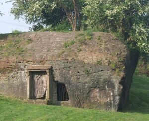
- Enter Edgars Field near the kid's playground. The shrine can be clearly seen ahead and slightly to the left, in the side of a rocky outcrop.
This is the only surviving rock-cut Roman shrine which is still in situ at its original location in the whole of western Europe. It dates from around AD 79, during the time of the emperor Vespasian, when the same area was being used to quarry stone for the construction of the Roman fortress (and, years later, possibly also Chester Castle) just over the river. It may have been the shrine of quarry workers, or it may have been used by travelers about to cross the River Dee (by a ford) - Minerva was Goddess of both craftsmen and travelers. She was the Etruscan counterpart to Greek Athena. The Roman Road headed south from here to the cattle trading site at Bovium (Tilston). In medieval times the figure was thought to represent the Virgin Mary and this may have saved it from destruction by vandals or quarrying. However, almost 2000 years of Chester weather have left the stonework badly damaged and no doubt 'acid rain' has caused further damage in recent times.
The Minerva shrine is located in Edgar's Field about 200m from the south end of the Old Dee Bridge. Edgar was Edgar the Pacific - some say he was the first king of all England (and you can find his sandstone 'gate' just at the other side of the bridge). The Minerva shrine is well sign-posted, but to get there just cross the Norman bridge Old Dee Bridge and turn right past the Ship Inn then follow the path past the playground. The shrine is on the rocky outcrop to the left of the path.
Near-by non-Roman
- Edgar's Field - Edgar the Pacific, (c. Aug 7, 943 – July 8, 975) was the great-grandson of Alfred and was famously crowned both at Bath and at Chester (in 973). King Edgar is said to have prayed in the minster (monasterium) of St. John after being rowed along the River Dee.
- Grosvenor Bridge - built between 1827-1833 in order to ease congestion on the Old Dee Bridge. At its opening, the Grosvenor Bridge was the greatest single-span stone arch road bridge – at 200 feet across and 60 feet high – in the world. It remained so for 30 years.
Grosvenor Museum
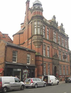
- The shortest route from the Minerva Shrine to the Grosvenor Museum is to cross the Old Dee Bridge and then head up St Mary's Hill - said to be the "steepest cobbled street" in England (and possibly the steepest residential street in the world - it isn't, but only just). Turn left on reaching Castle Street and then right into Grosvenor Street, where the museum is located.
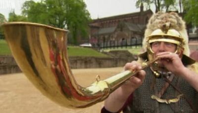
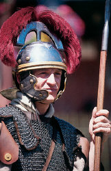
Next door to the Grosvenor Museum is the HQ of Chester's Roman soldiers. They can occasionaly be seen loading a white van with armour, shields and the like. They are more likely to be seen conducting parties of children around the city.
The Grosvenor Museum (official website) holds Chester's biggest collection of local and international history. It covers 2,000 years of Cestrian life spread over three floors of a classic 19th century building. It is truly one of the most interesting "local" museums in England and a "must see" when visiting Chester. And best of all – it's completely free! The Grosvenor Museum was founded in 1885, and its origins are linked to the start of the Chester Society for Natural Science, Literature and Art, founded by Charles Kingsley in 1871. Charles Kingsley was a Canon of Chester Cathedral from 1871 to 1873. He brought together many local naturalists, and the Society built up large and important natural history collections. The building of a local museum was first suggested in 1871, to house the collections and use them for teaching. Kingsley wrote many fictional works, but also wrote the lesser known "Town Geology" while in Chester.
The museum houses the largest collection of Roman tombstones from a single site in Britain. With a few exceptions, all the stones in the gallery had been reused at some time to repair the City Walls. The tombstones on display tell you something about the lives of the soldiers, slaves, women and children who lived in Roman Chester. The gallery takes you on a walk through a Roman cemetery. Four altars to Roman gods include one to Nemesis, the goddess of fate or destiny. Thirty five tombstones are on display. One of the finest pieces of Roman sculpture in the museum shows a fragment of a scene with a wounded barbarian lying defiantly under the legs of his opponent's horse. His spear is broken but he still clings onto his shield. The complete stone commemorated a Roman cavalryman whose name and likeness are now lost.
The first few tombstones were found in 1883. More were found in 1887, buried inside the lower part of the City Walls near the Phoenix Tower. Between 1883 and 1892, over 150 tombstones were found in the north wall. This is still the most spectacular archaeological find made in Chester. The walls were probably repaired later in the Roman period between 300 and 400 CE. Why the tombstones of previous Romans were used by later ones (probably from the same legion) to repair the walls is a mystery - it may reflect a time of extreme urgency, or religious differences between the two periods. However, the stones were well preserved inside the wall and survived unharmed for 1500 years.
Near-by non-Roman
- Chester Castle - one of the few castles in England or Wales that has been in constant use since first erected - unfortunately access to the Castle is now very limited;
- Military Museum - particularly concerned with the Cheshire Regiment;
- The grave of Thomas Gould - on the roundabout, the tomb of a private soldier who went through most of the Napoleonic Wars and was remembered by his friends with a gravestone that recounts his exploits all the way to Waterloo.
Roman "Quay"

- From the Grosvenor Museum, the Roman "Quay" is on the far side of the modern circular building next to the roundabout at the end of Grosvenor Street. There are actually some (a few square feet) "Roman remains" exposed in the center of the circular building, which appears to have been the site of a "high-status" building with mosaic floors. Many animal bones and oyster shells have also been found in the vicinity. Head towards the Roodee and then north along the City Walls. While a little of the quay can be seen from above and there is some signage about it, it is best viewed by going down steps onto the racecourse - which isn't possible on race days.
No oyster shells seem to have been recovered from Iron Age sites in Britain. However, Roman sites throughout the UK are renowned for the massive quantities of oyster shells. Contrary to assertions in the literature, no physical or documentary evidence has been found so far to indicate that the Romans introduced oyster cultivation to Britain. Although they used cultivation techniques in Italy, these would have been impractical and unnecessary in Britain. Oysters appear to have been an unexploited resource immediately prior to the Roman invasion. The claim that oysters were transported around Britain alive in lead tanks of salt water seems also to be highly unlikely and immensely impractical. Oysters will remain fresh for up to ten days if kept cool and packed closely to prevent opening of the valves (Pliny suggests they should be packed in snow - and the dangers of transporting oysters in the summer months may well be the origin of the advice not to eat them unless there is an "r" in the month - not from May through August). The Roman transport system was excellent by road, river and sea. Oysters may have been packed tight inside British made pots that were marketed to the Romans – black burnished-ware pottery manufactured on the southern shores of Poole Harbour in Dorset, adjacent to abundant natural oyster beds, was sent as far afield as Housesteads on Hadrian’s Wall, and probably shipped via Chester.
There as been much discussion about the so-called "Roman Quay", which extends for a considerable distance long the edge of the Roodee under the medieaval walls. Opposing theories have stated that Roman ships would tie-up along this "quay" for unloading, or that the "quay" is actually a defensive structure and the water depth over much of the Roodee would not have been sufficient, except perhaps at some high tides, for shipping to approach the "quay". Excavations for the construction of a gasworks (since demolished) revealed what could be interpreted as the far end of a pier, leading to the suggestion that this pier would be used for loading/unloading.
Sources and links
- 2000 years of eating oysters in the UK - how the Romans started a trend about "when there is an 'R' in the month". Well-written and well-worth reading;
Near-by non-Roman
- Watergate - For ships and cargoes arriving at the port of Chester, the Watergate was the main entrance into the city;
- Stanley Palace - Stanley Palace in Watergate Street is said (by some) to be Chester's finest Elizabethan house.
Chester "Roman Experience"
- Head back to Bridge Street. The "Dewa Roman Experience" is well signposted. There is an entry fee (see website for details).
St Michael stands on the site of the southern gate of Roman Chester and is one of several churches in Chester which are (or were) associated with Roman structures. The others were St Bridget on the opposite corner to St Michael and Holy Trinity which stands on the position of the Roman west-gate. It is possible that all three churches were cited to make use of Roman building materials.
The award winning Dewa Roman Experience is a fun and informative attraction. Visitors of all ages can enjoy wandering through reconstructed Roman Streets, exploring the archaeological remains and handling ancient relics in the "hands-on" studio. Dewa Roman Experience (http://www.dewaromanexperience.co.uk/experience.html) occupies a unique site at the heart of the original legionary fortress. In 1991 archaeologists discovered remains of the fortress on this site and the excavations have been left open for public viewing.
Near-by non-Roman
- St Michael - after the closure of the church in 1972 it was reopened by the city council as a heritage centre in 1975. It houses the "local interest" section of the Chester Archaeological Society Library. Update 2018: the Heritage Centre has now moved to the Grosvenor Museum where it now exists in a much diminished form;
The Baths (Cellar of "Spud-U-Like")
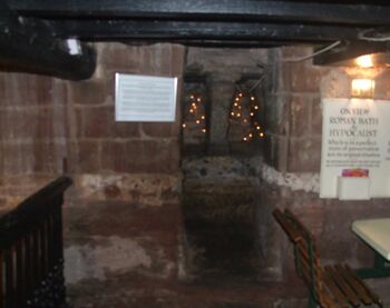
- The remains of the Roman baths are in the basement of "Spud-U-Like" - on the opposite side of Bridge Street from the "Roman Experience". You don't need to pay anything or buy a "spud" to see the remains, although eating a baked potato while looking at the remains of a Roman bath-house isn't that bad.
Like most Roman settlements, Deva Victrix had a large legionary bath complex for the soldiers to wash and to use for leisure time. The remains on the east side of Bridge Street were largely destroyed during the construction of the Grosvenor Mall. It has been estimated that the baths used between 500,000 and 750,000 litres of water a day, which was supplied from the springs in Boughton. Water was piped in large lead pipes underground from a branch off the main aqueduct near the Eastgate, downhill to the baths on Bridge Street. The water was then held in large tanks with concrete foundations, and then fed through the complex. Waste water would have been fed downhill using gravity to the river. The water was fed through 24 hours a day.
Some of the baths remains can be viewed in situ at 39 Bridge Street. In the west cellar wall are sections of Roman bath house masonry, and the medieval rear walling contains a rebated doorway opening into an exposed Roman hypocaust, perhaps restored when found during development in 1864; these roman remains are thought to date from the second century AD. They consist of 27 square columns in a rectangular chamber which originally contained 32 columns in eight rows of four. Also in the east wall are compound corbels, comprising of four stones, positioned over the doorway and dating to circa 1300.
Near-by non-Roman
- The Bridge Street Rows;

High Cross
- Head uphill along Bridge Street towards St Peter. The Rows are a relic of Roman Chester in the sense that when the Roman buildings collapsed they left mounds of rubble on either side of the street and later buildings were errected on top of these.
Formally known as the High Cross, but colloquially as just the Cross, the Cross can be found outside the door of St Peter's at the intersection of the four main streets in the midst of The Rows: (Northgate Street, Bridge Street, Eastgate Street and Watergate Street) that formed the original roads within Roman Chester. St Peter's church stands by the High Cross on the site of part of the Roman Praetorium and some of its fabric dates from that time. A church is said to have been built on this site by Æthelflæd in 907 when the Roman city was refortified by the Mercians.
Near-by non-Roman
- St Peter - On the northeast pier supporting the tower, just within the church, is a niche, and surrounding it is one of the best preserved medieval wall paintings in Cheshire - the others are in the Agricola Tower at Chester Castle and in St Johns. Please do not photograph any of these using flash, as it will eventually cause them to fade. Underneath the font lid is a noted Greek palindrome;
A Hidden Pillar

- To get here from the High Cross head down Watergate Street to Bishop Lloyd's House. There is a "New Age" shop called "Rainforest" at the row level. Take the narrow alleyway next to the shop at row level and the pillar is at the far end.
The praetentura, the houses of the six military tribunes, occupied the street frontage on the south side of Eastgate Street and Watergate Street. Unfortunately, reckless development during the 1960's destroyed any surviving structure. Dennis Petch, Curator of the Grosvenor Museum during the 1960s, is reported to have recalled bitterly (concerning later development of this location) that:
- "..the developer refused to give permission for any formal excavation once his work on the site had begun... with customary efficiency Laing's immediately commenced the earthworks for underground storage and delivery bays for shops to be built in the precinct above... it was soon clear that the great colonnaded hall under the arcade formed part of the same complex and was in all probability one of the earliest of the covered palaestrae of the north-western provinces of the Roman Empire. Even after the great size and high degree of preservation of the building had been clearly demonstrated, and protests against its impending destruction were made at local and national level, commercial considerations prevailed, effectively limiting our gathering of site data to piecemeal observation and recording at the pleasure of the contractor, supplemented by very little formal excavation. This was not a very satisfactory way of proceeding in the case of such an important building which had apparently begun its life in the early years of the fortress and was still in use in the third century. This debacle attracted a great deal of public attention and criticism, and the upshot was a general conviction that such vandalism should not be allowed to recur."
One relic of these buildings survives to the rear of Watergate Street. To find it, enter the covered passageway near Bishop Lloyd's House and at the far end look over the wall.
Near-by non-Roman
- Bishop Lloyd's House - (or Bishop Lloyd's Palace) is at 41 Watergate Street, and 51/53 Watergate Row, Chester, Cheshire, England. It is designated by English Heritage as a Grade I listed building. The architectural historian Nikolaus Pevsner considered it to be "perhaps the best" house in Chester.
- Leche House - Leche House is located at 17 Watergate Street and Row, Chester, Cheshire, England. It is designated by English Heritage as a Grade I listed building, and incorporates a section of the Chester Rows. It is considered (by some) to be the best preserved medieval town house in Chester.
Roman Strongroom
- From the "hidden pillar", retrace your steps along Watergate Street to the High Cross then turn into Northgate Street. On reaching the Market Square head down the alleyway next to the "Dublin Packet" pub. A few feet further on, the strongroom is on the right.
The central room at the rear of the Headquarters was the "sacellum", the regimental shrine, which served as a focal point of the headquarters. The standards of the units were kept here. In the centre of the room was a sunken pit which acted as a "strongroom" (Aerarium) for the regimental pay chest. The money was kept here to deter thieves who would be committing "sacrilege" if they stole from the shrine. The legionary standard bearers acted as treasurers of the funds keeping track of what money was paid in and out. The Roman strongroom can still be seen. To find it, walk along Northgate street to the market square and head down the alleyway next to the "Dublin Packet". It is a sunken pit dug into the local stone.
There is another Roman remnant visible through a transparent panel in the floor of near-by "Prêt-a-Manger" Cafe in Northgate Street. This is one of the columns from the Headquarters building.
Near-by non-Roman
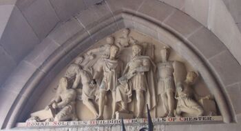
- Town Hall - Most of the time it is open to visitors (free of charge), but it is never that crowded. If you do visit, you can pick-up a free guide leaflet in the entrance. One amusing feature of the Town Hall is that some of the historical sculpture is a little less than accurate.
- Chester Cathedral - According to legend, a "prehistoric Druid temple" existed on this site, which was succeeded by a Roman temple dedicated to Apollo, and then, when Christianity became the state religion of Rome in the fourth century AD, the pagan temple may have become a Christian basilica on the site of the present cathedral.
Assorted Stones

- Head north on Northgate Street from the strongroom, past the Town Hall. The cluster of stones are towards the northern end of the square.
A cluster of stonework towards the upper end of the Market Square. The tall column is 18thCentury and has nothing to do with the Romans at all - it probably comes from the "Exchange" which was destroyed by fire on 30th December 1862. The one across the diagonal from the tall column is from the Roman Principia. The other two on the diagonals are from the Roman baths in Bridge Street and the gutter is from excavations in Princess Street.
Site of Corner Tower
- Continue up Northgate Street as far as the Northgate then get up onto the City Walls, then head west (downhill). Eventually you wil come to a bridge over the inner ring-road. This was the location of the corner tower. There is not much to see of the tower, but there are other things of interest nearby and you can continue to the Watertower and the Gloverstone, or even get down to the canal to look at the locks and docks.
The general belief is that the section of wall between Bonewaldesthorne’s Tower and Pemberton’s Parlour dates to the late eleventh or early twelfth centuries, and that the defences of the former Roman settlement were extended westward by the Saxons and later improved. However, it is possible that the Romans may have built some form of defensive work along this line to protect the extra-mural buildings which developed between the walls and the river. There does seem to be some very large stonework at the base of the walls which is very similar to the stonework used elsewhere in what is believed to be original Roman wall.
The walls were altered to form a raised promenade between 1701 and 1708, a walk that is about 2m wide. It is constructed from red coursed rubble sandstone. Approximately 1m north of the outer face of the wall can be seen a retaining wall of large red sandstone blocks which probably replaced the original earth bank. The south face of the wall has a 15m length with 5 courses of large stones set back a little from the face of adjoining lengths west and east, with a continuous course of rounded corbels immediately below the wall walk and thought to have been the base for the former inner timber palisade.
At this point the original walls of Roman Chester would have turned south and a further "corner tower" would have been located here. In the 1960s the Inner Ring Road, breaching the walls, was built. St Martin's Gate consists of a concrete arch, opened in 1966, to carry the wall walk over the road. The location of the corner tower has been marked out in cobbles at the base of the concrete steps leading down from the bridge - and that is all there is to see. Between 1323 and 1325, the Water Tower and spur wall from Bonewaldesthorne's Tower on the north-west corner of the City Walls were built at a cost of £100 to protect the harbour.
Near-by non-Roman
- Gloverstone - This lump of rock has at least 900 years of history, perhaps much more, and yet most visitors to Chester will never even see it;
- Watertower - Built between 1323 and 1325;

Roman parts of the City Walls
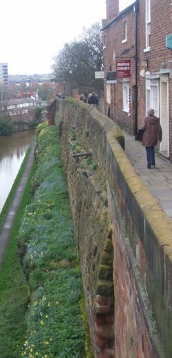
- The most well-preserved parts of the Roman City Walls are to the north and the east. If you have been following this route then head east from the corner tower (uphill) to the Northgate, either on the City Walls or following the canal tow-path. Eventually, this section of the Walls will lead you back to the Eastgate.
The walls of Roman Chester were built to a very high standard of large sandstone blocks without mortar, a technique known as opus caementicium and usually reserved for temple or city walls rather than those of a fortress. So one mystery is why did Chester get this special treatment, and why is Chester significantly (20%) larger than the any other Roman legionary fortress in Britain? One theory is that Chester was intended to be thew capital of the province of Britain. The presence of unusual buildings at the heart of the fortress – accounting for the area by which Deva was larger than other fortresses – has been taken as evidence that their construction was specifically ordered by the provincial governor.
The governor when construction first started was Gnaeus Julius Agricola. Lead piping (now in the Grosvenor Museum) found in the unique elliptical building bears his name. This is the only evidence in Britain of a building under the provincial governors direct control. These differences suggest that Deva may have been Agricola’s administrative headquarters – in effect the capital of Britannia. The section of wall heading north from Eastgate almost follows the line of the Roman walls, but not quite. In places the east-facing Roman walls would have been a few meters further to the east. The Roman walls of Chester were once thought to have been rebuilt in stone from the middle of the second century CE. There has been much debate on this. However, it now appears that the facing of the ramparts with stone started earlier and the rebuilding of the ramparts with solid stone was well underway by the end of the first century, i.e. within a few years of the establishment of the city. This would have been a massive undertaking, as the stone walls, towers and gates comprise some 55 thousand tons of stone (about 70 thousand Roman wagon-loads). Even after the Romans had built their stone walls there were still changes: from around 260-310 work at Chester was largely abandoned while the Twentieth Legion was fighting elsewhere. During this half-century, the ditch silted up and parts of the wall collapsed due to lack of maintenance.
Looking at the Braun and Hogenberg map (from 1581), we see something extending along the north wall of the city and down the east wall towards the Eastgate. Is this a road or possibly a ditch? Nowadays the canal, sitting in a rather deep cutting, follows the line of whatever this is along the north wall. There was a Roman ditch (fosse) before the wall but the depth of the cutting along the north wall seems excessive. However Simpson's "Walls of Chester" does seem to suggest that very little extra work was needed for the construction of the canal cutting:
- "The contractor for the canal when making his excavations found that he was exactly on the line of the old Roman fosse, and that, instead of excavating solid rock, he had only to clear out the accumulated earth and rubbish: by this economy he was enabled to make a considerable fortune."
The above version suggests that hardly any actual rock needed to be cut. However, maybe it is just an "urban legend".
Near-by non-Roman
- Phoenix Tower - where Charles I watched his army defeated during the Civil War.

Eastgate

- If you started at the Amphitheatre then this is the end of the trail, but if you didn't and want to get to the Amphitheatre from here, either follow the City Walls south to the Newgate (from which the Amphitheatre can be seen), or get off the walls and head down St John Street to reach the Amphitheatre.
Thomas Pennant, as quoted by Frank Simpson writes of it as follows (emphasis added):
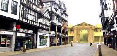
- " Of the four gates of the city,' says he," one of the East-gate, continued till of late years; it was of Roman architecture, and consisted of two arches, much hid by a tower , erected over it in later days . A few years ago it was pulled down, on account of its straitness and inconvenience, to give way to a magnificent gate, which rose in its place by the munificence of lord Grosvenor'. I remember the demolition of the ancient structure and on the taking down the more modem case of Norman masonry, the Roman appeared full in view. It consisted of two arches, formed of vast stones, fronting the Eastgate-street and the Forest-street; the pillars be them dividing the street exactly in two. The accurate representation of them by Mr. Wilkinson, of this city will give a stronger idea than words can convey; as also of the figure of the Roman soldier, placed between the tops of the arches, facing the Fores-street . This species of double gate was not unfrequent. The Portae, esquilina, and the Porte portesi, at Rome were of this kind. Flores, in his medals of the Roman colonies in Spain exhibits one of the coins of Merida, the ancient Emerita, particularly on those of Augustus, which shews that the colonists were proud of their gate; and perhaps not without reason, as it appears to have been the work of the best age. I must conclude, that the mode seems to have been derived from the Grecian architecture ; for at Athens stood a Dipylon or double gate now demolished - The East-gate faced the great Watling-street road, and the place where other military ways united. Through this was the greatest conflux of people which rendered the use of the double portal more requisite "
Indeed, there is part of an arch at the northern end of the gateway. It is tucked away by the stairs leading up to the walkway along the walls and forms part of the front of a very small shop selling refreshments.
Looking east from the Eastgate one cannot miss the bright blue watertower at Boughton. This was the source of Roman Chester's Water Supply, and is still the site of the Chester water-works today.
Near-by non-Roman
- Owen Jones memorial on the from of the once Grosvenor Club (now a bank) - linked to an intersting story of the rediscovery of the Roman lead mines in Wales, and some interesting coats of arms;
Sources and Links
Related Pages
- Roman Chester;
- City Walls: a guide to the city walls, including both the Roman parts (much reconstructed) and the extension by the Anglo-Saxons (entry is free);
- Legio II: what is known about the history of the second legion, including their time in Chester;
- Legio XX: what is known about the history of the tenth legion, including their time in Chester;
- Grosvenor Museum: contains the largest collection of Roman tombstones in Britain, some of which are military (entry is free). Has a small shop, with some books;
- Amphitheatre: a guide and history about the remains of the amphitheatre in Chester (entry is free)
- Minerva Shrine:
- List of Roman finds (defences)
Online
- Tours with "Roman Soldiers" - you can hire a "real Roman" tour guide;
- The BBC reports on the Romans (video);
- Another guide from "Cheshire Now";
- A further guide from ChesterTourist.com;
- A tour in Wales by Thomas Pennant provides a guide to Roman Chester from 1773.
